Monitoring D.C.'s Growth With Landsat
Yesterday was the 40th anniversary of the Landsat system, a group of satellites that offer scientists a continuous view of the earth.
"The data from the satellites provide a permanent, objective record of land conditions and are routinely used to measure and monitor changes brought on by natural or anthropological events and actions," according to the U.S. Geological Survey, which operates the system in partnership with NASA.
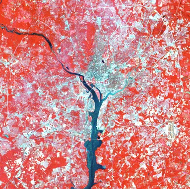
Here's an example. Four decades ago, the system took this color infrared image of the Washington, D.C., area. "The red tones represent forests and large grassy areas. The light tones indicate cleared fields and the highly reflective impervious areas of urban development," according to USGS:

Landsat also captured this image earlier in 2012. "A comparison of the two images illustrates the significant growth in the greater D.C. area," the agency said:

More about the Landsat system here: