Mapping South Korea's Foreigners

Note: My family last year relocated to Seoul, where my wife is working as a foreign correspondent for NPR. This post is part of an occasional series profiling the peninsula’s demographics and politics.
This week I looked at the population of foreign residents in South Korea, charting national origin and geographic distribution around the country. But if you don't live here (and even if you do) that geography can be quite difficult to absorb without maps.
So, after a year of procrastination, I finally got the courage to tackle the detailed census and geography files from the Korean Statistical Information Service (you try loading Hangul characters in a database!).
And then I made some maps, plotting the number of foreigners per 1,000 total residents — by Seoul neighborhood, county/municipality and province.
First, the capital city. Seoul is home to about 9.7 million residents within its city limits, and it's obviously the center of political and economic activity in South Korea, giving it a relatively high proportion of foreigners. Seoul is roughly the size of Chicago (230 square miles), and has about 17 foreigners per 1,000 residents.
My neighborhood, Hangangno-dong, is the red highlighted polygon in the center. It's a single square mile, and it has about 48 foreigners per 1,000 residents. Here's the map:

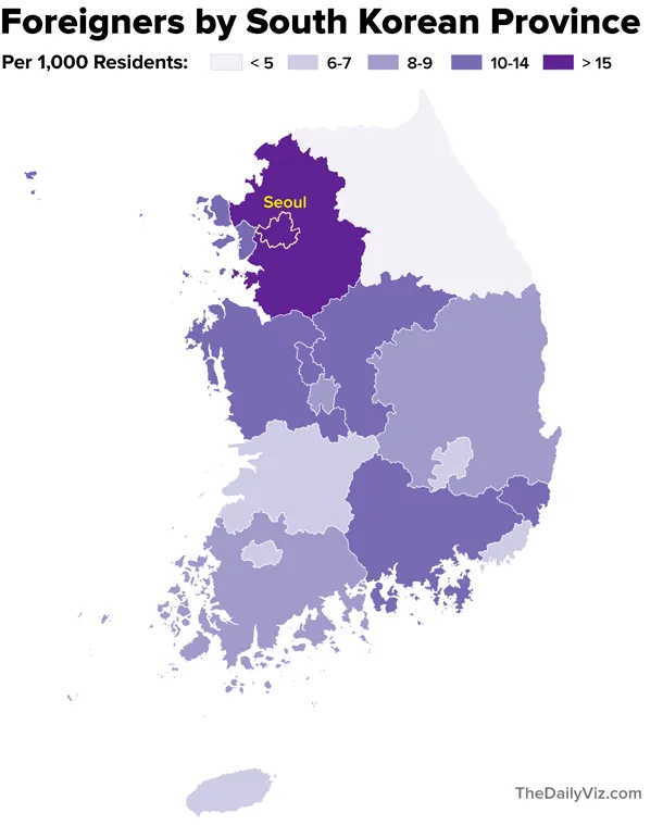
South Korea has 16 provinces and major cities that are grouped together administratively, like America's states. Seoul and adjacent Gyeonggi province, the nation's most-populous state, have the highest proportions of foreign residents. Here's the map:

South Korea also has some 250 smaller administrative areas — call them municipalities, or townships, or mid-size cities — that are essentially like counties in America. Here's that map (again, Seoul is highlighted).
The dark purple area south of Seoul is Jincheon County, a relatively small community (60,000 residents) known for its agriculture. The dark area in the far south is Yeongam County, which has roughly the same population. But it's home to a big Hyundai heavy industries plant. Perhaps a high proportion of foreigners (many from southeast Asia work in factories) live in these areas for work.
Making these maps was good practice for familiarizing myself with Korean geography and demographics, but they aren't super useful for foreigners without more labeling, annotation and context (and perhaps background features). Next time...
Notes: The data reflect the 2010 census, the latest available at all geography levels. As I mentioned, making sense of mapping files here is tough. A huge thanks to these fine folks for making it easier.