Obama's bin Laden Speech
A word cloud President Obama’s remarks last night on the death of Osama bin Laden:
Read more →
Mapping Yesterday's Tornadoes
The National Weather Service has tons of free data available online, including a daily list of tornadoes. Here’s a map of yesterday’s 164 events, which occurred in 14 states. That’s almost the three-year average of 185, according to the agency. Here’s a map:
View interactive version.
Read more →
Congressional Campaign Totals
Members of Congress recently filed their quarterly campaign-finance reports, which detail their political fundraising, spending, cash on hand and debts. The Center for Responsive Politics posted the totals for all House and Senate members yesterday. This map shows fundraising totals by state:
...
Read more →
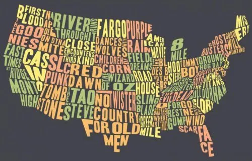
The United States of Movies
This word map visualizes places where popular movies were filmed:
Via Brandishing Bonnets | H/T Jamie Vernon
Read more →
iPhone Travel
I ditched the BlackBerry two years ago this week. Here’s where I’ve been since my iPhone started logging my travel coordinates (56,000 records and counting):
Built with Fusion Tables.
Read more →
Closing Texas' Budget Shortfall
At work we developed an app that allows readers to make choices in an effort to close the state’s $27 billion shortfall.
Texas lawmakers have six weeks left in the regular session, and their struggle with the state’s tight budget is expected to take up much of that time. It could even push th...
Read more →
The Politics of Redistricting
A cross-post from my work blog:
As state Sen. Kel Seliger said last week, the decennial process of drawing the boundaries around legislative districts is inherently political, a fact that’s apparent by looking at the maps themselves.
Take the case of state Rep. Aaron Peña, R-Edinburg, who follo...
Read more →
Taxes in Context
A cool new tool for analyzing federal income tax burdens over time from Remapping Debate:
… [U]sers will be able to make a host of observations. Two that we’ve noted: the halving of the tax burden from 1945 to 2011 for a married couple with taxable income (in 2010 dollars) of $1,000,000 saves ...
Read more →
On the Records: Mapping Highway Speeds by State
On the Records: Mapping Highway Speeds by State
Read more →