Posts tagged "ArcGIS"
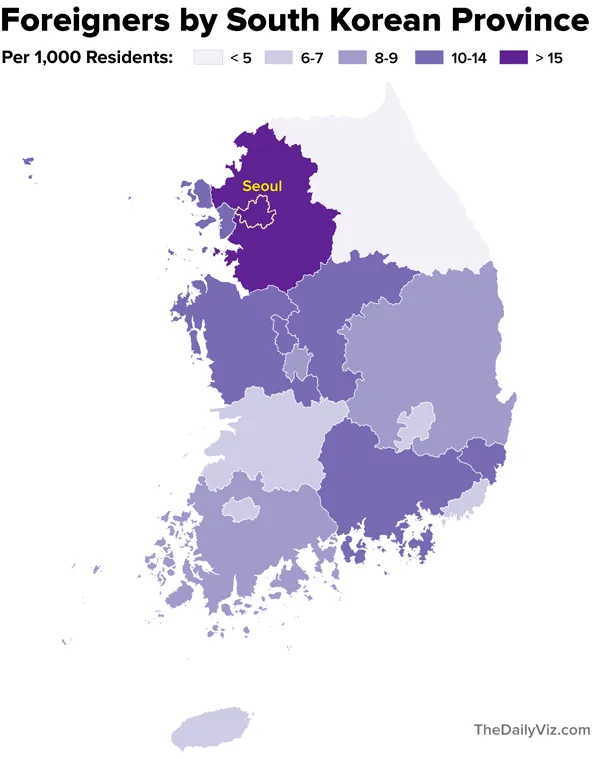
Mapping South Korea's Foreigners
Note: My family last year relocated to Seoul, where my wife is working as a foreign correspondent for NPR. This post is part of an occasional series profiling the peninsula’s demographics and...
Read more →
Mapping Obama's Election Performance By County In 2012 Vs. 2008
The Washington Post over the weekend published an interesting story about President Obama's southern support in the election: The nation’s first black president finished more strongly in the region than...
Read more →
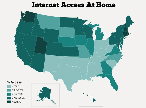
Mapping Internet Access In U.S. Homes
About three quarters of Americans have access to the Internet at home, according to a new survey released this week by the U.S. Census Bureau. New Hampshire, Washington and Utah...
Read more →
Mapping Asian Population Density With Census Data
Asians were the fastest-growing racial group in the United States from 2000-2010, growing by nearly 30 percent in most states, according to a new report by the U.S. Census Bureau...
Read more →
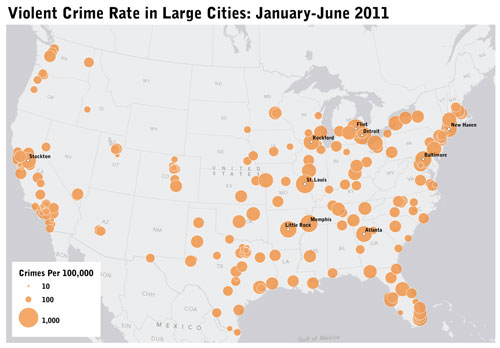
Mapping Violent Crime, Murder Rates with FBI Data
The FBI today released its mid-year crime figures from large cities around the county, and the data are positive, NPR reports: The number of violent crimes reported by 12,500 U.S. law enforcement...
Read more →
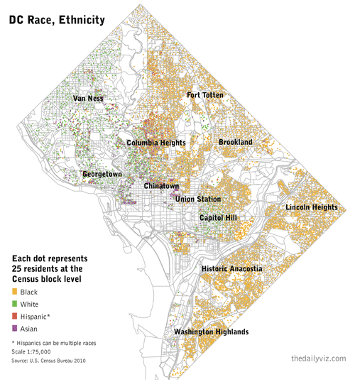
A 'Radical' View of DC's Demographics
I’ve been obsessed with William Rankin’s ‘radical cartography’ site for more than a year. One map in particular — a detailed view of Washington, D.C.’s segregated neighborhoods — has stuck...
Read more →
Mapping Where GOP Candidates Raise Their Campaign Donations
Federal Election Commission records show Republican presidential candidates have raised about $90 million through the third quarter of this year — but where is the money coming from? These maps visualize the geographic source...
Read more →
Mapping Political Power in The Netherlands
I spent the last few days in The Hague, the seat of Dutch government. One of the highlights was a visit to the country’s lower house in Parliament, called the...
Read more →
Mapping ONA Attendees
More than 1,000 people were on the attendee list for last weekend’s Online News Association convention in Boston, according to a list the organizers graciously released. The data weren’t perfect. Only...
Read more →
Mapping American Poverty
A national map prompted by today’s news about Americans in poverty: WASHINGTON — The portion of Americans living in poverty last year rose to the highest level since 1993, the...
Read more →
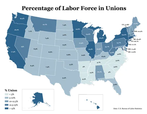
Union Membership by State
In the early 1970s, one in four American workers belong to a labor union. Last year, they represented about 12 percent of the workforce, according to the Bureau of Labor...
Read more →
Goodbye Irene
Hurricane Irene is now gone, though the storm damage is still being felt across the East Coast. In D.C., at least for me, that meant a short disruption in power...
Read more →
A Sea of Hurricanes
I thought moving to Texas might spare me the nuisance of hurricanes. I was wrong. Hurricane Irene is churning north through the Atlantic, threatening to knock out power in D.C....
Read more →
Mapping Earthquake Intensity By East Coast Zip Codes
Early tonight the USGS released data summarizing Americans’ responses to today’s earthquake by ZIP code. The agency uses a complicated formula that’s different from the commonly known Richter magnitude scale, but basically...
Read more →
Rick Perry: Fundraiser
Now that Texas Gov. Rick Perry, R-Texas, is officially in the presidential race, reporters are noting his campaign fundraising prowess as a possible strength that could propel him to the GOP nomination: ...
Read more →
Mapping the New York Senate Same-Sex Marriage Vote
As we all know, the New York Senate on Friday voted to approve same-sex marriages. These maps, made with ArcGIS, visualize the districts by vote, seniority and political party. First,...
Read more →
Mapping Unemployment Change by U.S. Counties
Nationally, the unemployment rate fell less than one percentage point from April 2010 to April 2011. But not all areas of the country are the same. This map, made with...
Read more →
The Politics of Redistricting
A cross-post from my work blog: As state Sen. Kel Seliger said last week, the decennial process of drawing the boundaries around legislative districts is inherently political, a fact that’s...
Read more →