Posts tagged "Weather"
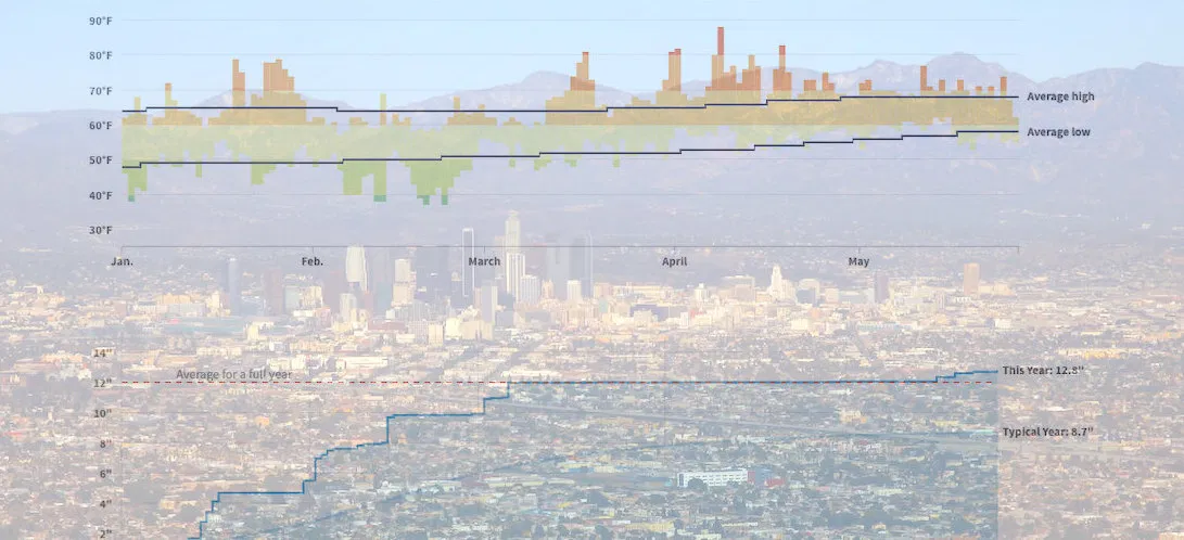
How Wacky Has LA's Weather Been in 2019? These Charts Help Explain
The famously temperate* weather in Los Angeles just can't quite figure itself out this year. This year brought "Snowing in Calabasas!", which was part of the "February to remembrrr", and...
Read more →
It's Been a Hot Summer, Down Under
My family is vacationing this week in Mosman, Australia, a harbourside Sydney suburb near Balmoral Beach known for its family friendly attractions and boutique shops. This place is a great...
Read more →
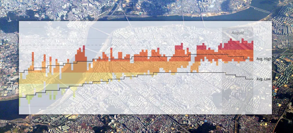
Seoul's Steamy Summer (Updated)
Note: I followed my wife, a foreign correspondent for NPR News, to Seoul last year. This is one of a series of posts exploring our adopted country's demographics, politics and...
Read more →
Someday I'll Say Goodbye to Seoul. I Might Miss the Weather.
Note: I followed my wife, a foreign correspondent for NPR News, to Seoul last year. This is one of a series of posts exploring our adopted country's demographics, politics and...
Read more →
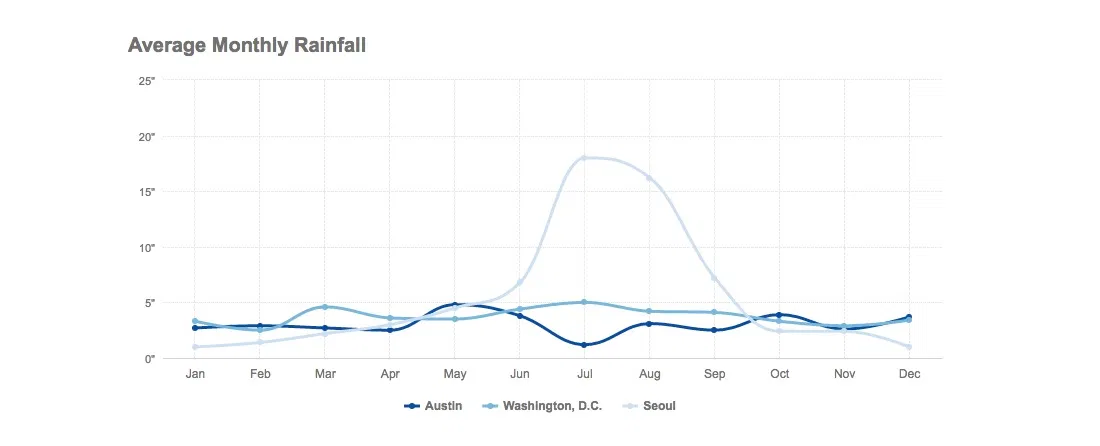
DC, Seoul Share Similar Climate — Until The Summer Rains Come
As I noted yesterday, we can expect similar weather here in Seoul as we experienced in Washington, D.C., where we lived until earlier this month. The two capital cities are...
Read more →
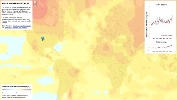
Mapping 'Your Warming World'
New Scientist has published a fascinating interactive map related to increasing global temperatures over time: The graphs and maps all show changes relative to average temperatures for the three decades...
Read more →
Humidity, Sunshine Across The U.S.
With summer winding down, I wondered: How much does the amount of sunshine and humidity vary among U.S. cities? First, this map shows the average percentage of possible sunshine by...
Read more →
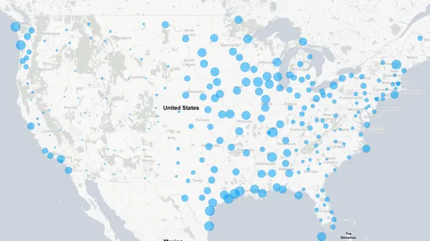
Mapping Wildfire Danger
Our latest work project transforms the static federal wildfire danger forecast into an interactive map. We released it today: Users can view the full country map or find their location...
Read more →
BRB
Escaping the heat to visit Montreal this weekend. See you Monday.
Read more →
A Below-Average Birthday
Today's my birthday, and the weather is great. What's it been like for past birthdays, I wondered. The answer: All over the place (sort of like my parents' moving choices)....
Read more →
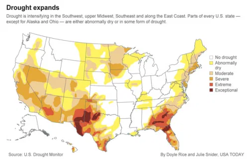
Mapping Drought Conditions
USA Today reports that the country hasn’t been this “dry” in five years: Still reeling from devastating drought that led to at least $10 billion in agricultural losses across Texas...
Read more →
Mapping Surface Wind
Hint.fm visualizes surface wind from the National Digital Forecast Database:
View larger, live version and archive.
H/T @blettenberger
Read more →
Our Warm Januaries
Last month was the fourth-warmest January in the contiguous United States on record, according to the National Oceanic and Atmospheric Administration. This chart shows three decades of Januaries. Red bars...
Read more →
Houston's Record Weather Year
Great work by the Houston Chronicle’s graphics director, Jay Carr:
Larger version | Via Eric ‘SciGuy’ Berger
Read more →
A Warmer Winter For Some
These maps capture the warm winter we’re experiencing in the Mid-Atlantic and Northeast states. The top map shows the average temperature so far this December. The bottom map shows how...
Read more →
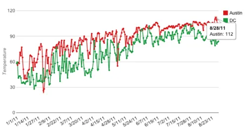
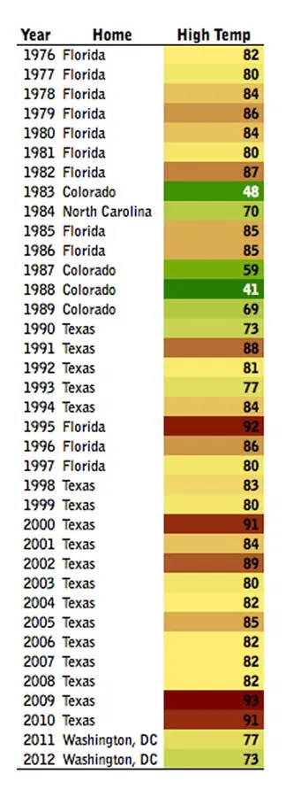
DC vs. Austin Weather: Part 2
Back in May I compared the weather in my former town, Austin, Texas, to my current home, Washington, DC. Now that I’ve lived through a summer here, I’ve revisited the...
Read more →
Irene: $7 Billion Disaster
Add Irene to this map of billion-dollar weather disasters. In fact, the storm could be one on of the top 10 costliest ever:
See larger PDF version | Source: NOAA
Read more →
Goodbye Irene
Hurricane Irene is now gone, though the storm damage is still being felt across the East Coast. In D.C., at least for me, that meant a short disruption in power...
Read more →
Tracking Irene
From the National Hurricane Center:
View interactive version
Read more →
NOAA's Climate Change Library
The city of Chicago is planning ahead for climate change, choosing different paving materials and plants in anticipation of warmer temperatures, according to this story in The New York Times....
Read more →
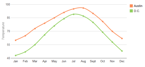
DC vs. Austin Weather
I love Austin, but my biggest complaint about Texas’ capitol city is the oppressive summer heat. And when I say summer, I mean April to October. Today’s high temperature is...
Read more →
Mapping Yesterday's Tornadoes
The National Weather Service has tons of free data available online, including a daily list of tornadoes. Here’s a map of yesterday’s 164 events, which occurred in 14 states. That’s almost...
Read more →