FiveThirtyEight Chat On Maps: Turning The "Big" States Blue
The folks at FiveThirtyEight had a fun data visualization discussion during their regular election chat this week, about whether Hillary Clinton should focus on ensuring victory next month or spending more money in "red" states to expand her Electoral College map.
Nate Silver chimes in by alluding to the classic discussion about how choropleth maps of the United States in a political context can distort a story. That's because geographically large but sparsely populated western states skew the picture.
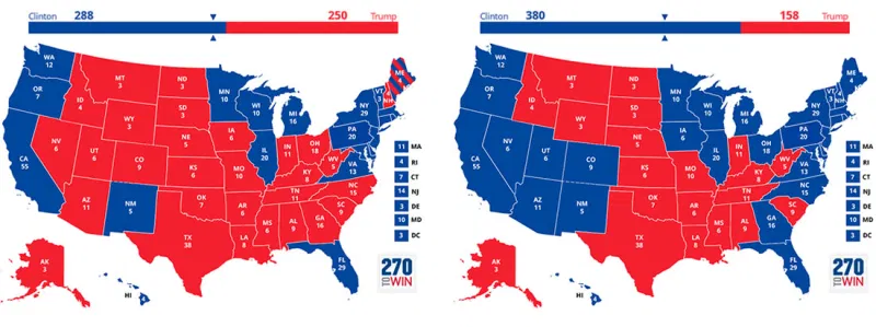
harry: People look to the map to understand how big the victory was. We have a winner-take-all system.
micah: Yeah, if the map everyone sees on Nov. 9 is covered in blue, doesn’t that make a difference?
clare.malone: I think it’s a reasonable goal for them to want to/try to win at least one unexpected state. A spot of blue in a sea of red can be a striking visual that people walk away with.
natesilver: So should they aim for states that are physically larger because they’re more impressive on the map?
clare.malone: Hah, yes.
natesilver: So Alaska then?
clare.malone: No.
natesilver: Or not Alaska because it gets shrunken down?
harry: Is this a Mercator problem? I don’t know maps.
Good stuff.
Of course, she could always try to win like Raegan did in 1984 — and then it won't matter how you visualize it: